
An interdisciplinary and transdisciplinary approach to transformative adaptation in the Kutch mangroves
By Nobuhito Ohte, Kyoto University
Before joining the TAPESTRY project, I was an ordinary hydrologist and ecologist conducting research based on fieldwork, mainly in Japan. My main research interest was the ecosystem dynamics of forests, and I was also interested in and had some research experience with mangrove ecosystems, which are one of the focuses in the TAPESTRY project. The members of the TAPESTRY project are composed of researchers in the social and natural sciences, and I am one of the active natural scientists in the project.
In this blog post, I discuss how interdisciplinary and transdisciplinary research is conducted in the TAPESTRY project. In other words, it is about how natural scientists like myself and social scientists are working together, and what effect this has for us. I will also show how interdisciplinary research is conducted, not only through collaboration between scientists in the natural sciences and humanities, but also with the help of stakeholders in the community.
In Kutch, one of the ‘patches’ of our project, the objective of our research is to identify what practices are needed for transformations towards more sustainable futures for pastoralist communities living in marginal social environments.
While the need for sociological and anthropological research is obvious, I would like to personally emphasize the need for information obtained through natural scientific research, in order to consider social change.
This is because, in Kutch, it is important to understand the characteristics of the environment and ecosystems, and their historical evolution, to understand the origins of the environment within which society operates. Specifically, we need to know, for example, how people use the surrounding ecosystems for their livelihoods.
With this information, social scientists can use sociological methods to understand how local people perceive and use the ecosystem dynamics and ecosystem services surrounding their communities, and on what norms this is based. This means there is a need for cooperation and interdisciplinary research between both types of researchers.

Working together and communicating
But this cooperation is not only between researchers. Interdisciplinary research requires mutual communication between social scientists, natural scientists, and communities as well. While communication with the local community may be a natural activity for social scientists, natural scientists do not have much experience in communicating with local people, generally speaking.
Mutual collaboration between social scientists and natural scientists is also not a very easy task in practice. As a side note, when the TAPESTRY project started, as a natural scientist, I was puzzled by the differences in style between the fieldwork conducted by cultural anthropologists and that conducted by us ecologists.
Since the former involves people and the latter involves natural flora, fauna, and phenomena, the length of a single survey and the time required to process materials and samples after the survey were completely different. In the early stages of the project, I felt it was important for both social and natural scientists to understand that there were differences regarding methodology between the two parties, and to take care so that the other party would feel comfortable conducting the surveys and investigations.
At the stage when the results of the investigations are being produced, mutual understanding is expected to progress, as both sides will naturally become more active in their discussions regarding the findings obtained.
Research among pastoralists and mangroves
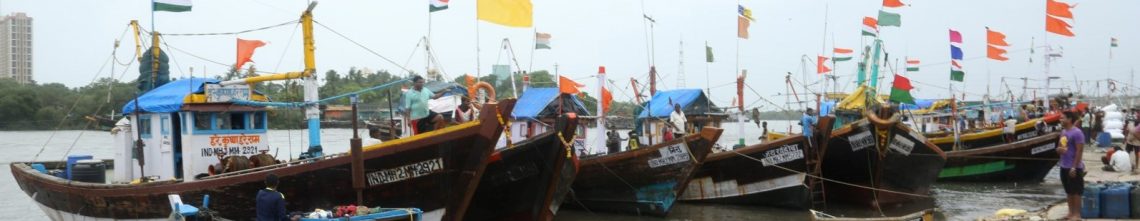
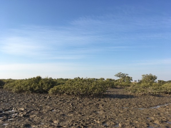
One of the sites of the TAPESTRY project is a coastal mangrove ecosystem in the province of Kutch. Mangroves have traditionally been used sustainably by neighbouring pastoralists. They have been continued the traditional herding of Kharai camels, using mangrove leaves as major fodder. These pastoralists have given names to each of the mangrove-covered islands.

We began our research by identifying the target islands from the pastoralists’ narratives. During this phase, we needed to communicate with them, explaining that we were trying to conduct a survey that would be beneficial for the livelihoods of the local people, and asking them to share geographical information about the mangrove islands. For this phase, we used participatory mapping, a method used in social science research and communication with local people.
The data has been obtained as the result of a long-term assessment of mangrove plant activity on each island, called Chers, using satellite remote sensing data (Figure 1). The time period is from 1988 to 2019. The data used in the analysis was the Landsat satellite images provided by NASA/USGS. The NDVI (Normalized Difference Vegetation Index), an index calculated from satellite imagery data, can be used to express the increase or decrease in tree canopy biomass.

The results show that the biomass of the mangrove patches they were using as grazing land had been consistently increasing since the 1980s, even before the local government imposed access restrictions on the islands after 2005. This showed that the use of mangrove leaf biomass in their camel feeding did not inhibit the growth of mangrove forests, and did not lead to their decline.
Lessons from working together
Prior to joining the TAPESTRY project, I had no experience working with social science researchers. Nor had I worked with the local people who were the subjects of the research. To be honest, I learned that it is not easy for researchers from different disciplines to work together on a project, especially during the earlier period; but on the other hand, I also realized the importance of it.
Towards the end of the project, we had an opportunity to present the results from the satellite imagery described above to local pastoralists at one of the workshops. They accepted the results with great joy. This was a great joy for us too. But at the same time, they wanted us to explain to them in simple terms how and what we were doing, how we could do such investigations. This was understandable.
We also aimed to provide a clear picture of the entire research to the local people and pastoralists. This required us natural scientists to use the communication methods that social scientists have. In other words, in this latter phase of the project, it’s been necessary for natural scientists and social scientists to cooperate with each other again to communicate with stakeholders in the study area.
